Not the Trip We Planned- Backpacking in the Mt. Adams Wilderness, August 17-21/2026.
By Ken Roley
What would you do if the backpacking trip you planned for months was cancelled due to an out-of-control forest fire? Well, it happened, and unfortunately, it’s probably not the last time. Our planned five-day hike around Mt. Hood on the Timberline Trail, was canceled due to the Grasshopper fire which eventually burned more than 93,000 acres including most of the Badger Creek Wilderness. With the heavy smoke and evacuation orders in place, hiking the Timberline Trail was not going to happen, and it was time to implement Plan B. The only trouble was, we had no Plan B. We needed a backpacking area and new itinerary, and we needed it quickly, with less than two weeks from our departure date. We needed an area without nearby wildfires and trails presenting similar challenges as Mt. Hood. Fortunately, the Mt. Adams Wilderness fit the bill perfectly.
Mt. Adams is about 60 miles due north of Mt. Hood in Washington state. At 12,276 feet it is the second highest peak in the state behind Mt. Rainer. The Pacific Crest Trail (PCT) crosses the west slope of the mountain while the east side is contained within the Yakama Indian Reservation. There’s no trail system on Mt. Adams allowing you to circumnavigate the mountain, like the Timberline Trail. A few people do hike around Mt. Adams, which requires special permits from the tribe to access the east side of the mountain. The terrain is described as “extremely challenging”, with snow fields to cross and a 5-7 mile section with no trail. Circumnavigating Mt. Adams was more of a challenge that what we were looking for. However, there are some great trails along the west and north flanks of the mountain, allowing access above the tree line, camping at alpine lakes, and fantastic views.
With our new itinerary and map of the area, it looked like we were all set, and updated details was sent to all those on the sign-up list. A day later, a new fire was noted in the “Watch Duty” app on my cell phone, five miles from our starting point, and it looked like our trip would be canceled yet again. Fortunately, the fire was small, started by a lightning strike, and the Forest Service got it put out quickly. With no other fires in the immediate area, the trip was back on. Great!!!
On our way to the Killen Creek Trailhead, where we would start our trek in the Mt. Adams Wilderness, we stopped at the Trout Lake Forest Service Station to get the latest news about fire conditions and to pick-up an updated wilderness map. The trailhead was another 20 miles over a rough road with giant potholes to navigate. Finally, we reached the trailhead, and hiked five miles to Sly Lake, our base camp for the next two days. This beautiful lake is just a short distance from the PCT and welcomed us with a sandy beach and tantalizing warm water.
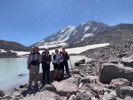
The next morning, we packed for the day and headed towards the base of Mt. Adams. We had lunch at High Camp (located at tree line) and enjoyed the beautiful close-up views of Mt. Adams. After lunch, we continued to Glacier Lake at 7,200 feet. Glacier Lake is a moraine-damned lake at the foot of Mt. Adams. Getting there turned out to be an arduous task climbing over several rock slides the last 1.5 miles. Even though the Gaia mapping tool indicated three trails to Glacier Lake from High Camp, these trails were not on the official forest service wilderness map, and it was evident they were not being maintained. (I’ve notified Gaia GPS and recommended they update their base map.) After trekking over and around the rockslides, we were rewarded with a beautiful blue lake where we could relax, have a snack, and enjoy the view we had worked so hard to obtain.
The next day we said goodbye to Sly Lake and moved our camp to Foggy Flats, about three miles away. That afternoon we hiked up the Muddy Creek drainage on the Highline Trail enjoying another beautiful day. Along the way we were entertained by the Pikas living along the trail who called out warnings to their furry friends that human invaders had entered their territory.
At Foggy Flats we awoke with sunny skies and condensation dripping inside our tents. This likely resulted from camping in a wet meadow with a stream nearby. We hiked north to Muddy Meadows on an easy downhill trail and from there to Killen Campground. The next morning, after being awakened by a noisy crow, we packed up and hiked a short distance to our cars, completing our 26-mile loop, and headed for home.
On our way we stopped in Hood River at the Trailforks Restaurant for delicious hamburgers and french fries. After five days of trail food, the hamburgers tasted so good!!! The weather was perfect, the mountain was beautiful, the trail wasn’t crowded, and everyone had a great time, even though it was not the trip we planned.
Chemeketans participating included Sherry McConnell, Marie Flores, Haley Rivers, and Ken Roley (Leader).
Enjoying the beautiful view of Mt. Adams from Glacier Lake.
From left to right, Ken Roley (trip leader), Marie Flores, Haley Rivers, and Sherry McConnell.
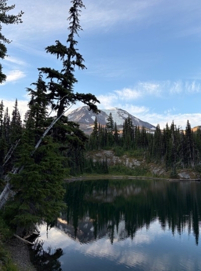
Sly Lake, Mt. Adams Wilderness.
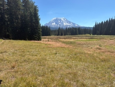
Muddy Meadows with Mt. Adams in the background.